We explain what the meridians and parallels are, the characteristics of each one and how they are used. In addition, geographical coordinates.
-
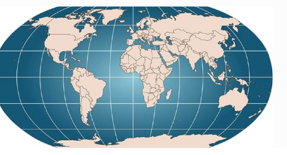
What are meridians and parallels?
The meridians and parallels are two types of imaginary lines with which the world is usually organized geographically . With them, a coordinate system is constructed that allows you to accurately locate any point on the globe based on its latitude and longitude.
Specifically the meridians are the vertical lines with which we can segment the globe into equal portions. They are all born in the North Pole and extend to the South (or vice versa).
For their part, the parallels are the horizontal lines that do the same. The parallel 0 is the equator. The other parallels are repeated by drawing smaller circles in both the Northern and Southern hemispheres. The combination of these two sets of lines forms a grid.
Both types of lines have a reference point from which to enumerate both meridians and parallels, using sexagesimal degrees (expressed as follows: degrees °, minutes ‘and seconds’):
- The meridians are measured at the rate of one degree (1 °) for each one, starting from the so-called 0 ° Meridian or Greenwich Meridian , which is the one that passes through that exact London location, where the Royal Greenwich Observatory was once. From there the meridians can be considered East or West, depending on which direction they are in relation to this axis, and the globe is divided into 360 segments or “segments”.
- The parallels are measured from the equator, considering the angle they form with respect to the Earth’s axis of rotation : 15 °, 30 °, 45 °, 60 ° and 75 °, both in the Northern Hemisphere (30 ° N, for example ), as South (30 ° S).
The application effect of this system translates into:
- The time zone system , determined by the meridians . The GMT ( Greenwich Meridian Time , “Greenwich Mean Time”) format is currently used to express the time in any region of the world, adding or subtracting hours depending on the meridians with which each country is governed. For example, the Argentine time zone is GMT-3, while the Pakistani is GMT + 5.
- The terrestrial climate system, determined by the parallels . From the so-called five notable parallels, which are (from North to South): the Arctic Circle (66 ° 32 ’30’ ‘N), the Tropic of Cancer (23 ° 27’ N), the equator (0 ° ), the Tropic of Capricorn (23 ° 27 ‘S) and the Antarctic Circle (66 ° 33’ S), the globe is classified into climatic or geo-astronomical zones, which are: The intertropical zone, the two temperate zones and two glacial or polar areas. Each one has similar climatic conditions due to its latitudinal location.
- The global coordinate system , which allows geolocation tools such as GPS ( Global Positioning System , “Global Location System”).
-
Geographical coordinates
As we have seen in the previous cases, a sort of grid emerges from the union of meridians (longitude) and parallels (latitude). This geographic coordinate system consists of the expression of the value of a geographical point from its numerical record of latitude and longitude in sexagesimal degrees.
For example, the geographical coordinates of Moscow are 55 ° 45 ‘8’ ‘N (that is, its latitude in the Northern Hemisphere is between the 55 and 56 parallel) and 37 ° 36’ 56 ” E (that is, its length is between meridian 37 and 38). With this system, satellite location mechanisms such as GPS operate today.


